

Road & Rail Networks

The Northern Corridor is a complex, multimodal transport ecosystem linking the maritime Port of Mombasa to the heart of the Great Lakes Region. NCTTCA is dedicated to transforming this network into an efficient and sustainable development pathway by coordinating the planning, maintenance, and modernization of critical physical assets. From the deep-water berths of Mombasa to the road, rail, and pipeline arteries reaching our landlocked Member States, we ensure that infrastructure development aligns with international standards to reduce transit times and enhance regional integration.

The Road Network

The Northern Corridor road networks cover approximately 12,707 Km in length, distributed as follows: 567 Km in Burundi; 4,162 Km in DRC; 1,328.6 Km in Kenya; 1,039.4 Km in Rwanda; 3,543 Km in South Sudan; and 2,072 Km in Uganda.

According to data collected in the Member States;
  • Kenya: 88% of roads are in good condition, paved and tarmac, with an average IRI below 2.9 mm/m. Only 8% of the roads are in fair condition, while 4% are in bad condition.
  • Rwanda: Most roads in Rwanda, about 93 %, are in good condition. The remaining 7 % are under rehabilitation and widening of lanes, as well as upgrading works from earth to paved roads.
  • Burundi: 41% of the roads are in good condition; 41% in fair condition, and 18% (93 Km) of the roads are still in poor condition
  • DRC: 42 % (1,752 Km) of the road condition in DRC is in a good state, 29 % (1,213 km) in fair condition, and 29%, or an equivalent of 1,207 km, is in a bad state. The majority of roads in DRC are two-lane, with a width of 3 to 3.5 Meters.
  • South Sudan: A majority, at 95 %, of the corridor road in South Sudan is in bad condition, and 5% is in fair condition.


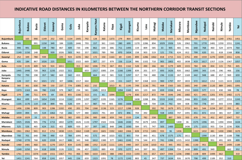
Indicative road distances in Kilometers between the northern corridor transit sections

Road transport routes

Key transit transport routes are from Mombasa to Bujumbura (the South-West terminus) covering about 2,000 km of road distance, and the Mombasa – Kisangani route which stretches for about 3,000 km. The bulk of imports and exports to and from countries in the Corridor is transported via either of these transit routes.

From Kenya to Uganda, the Mombasa – Malaba – Kampala road (1170 km) is preferred due to the relatively good quality of the network and availability of social amenities en route. The alternative route is Mombasa – Kisumu – Busia – Kampala.

The average transit time from Mombasa to Kampala in 2016 was 5 days. View the details for Average Transit Time from Mombasa to various destinations

From Uganda to Rwanda, the principal routes are Kampala – Kagitumba – Kigali and Kampala – Gatuna – Kigali; Bujumbura in Burundi is reached from Kampala through Rwanda. Bukavu, Goma, and Kisangani are also reachable from Rwanda and Uganda.

The Northern Corridor Secretariat is advocating for a much shorter route from Mombasa to Kigali and Bujumbura via the Voi-Taveta/Holili-Arusha-Siginda Road: 1,650 km to Kigali & 1,957 km to Bujumbura.

The Rail Network

East African Regional cooperation initiatives have mainly focused on joint efforts to modernize railway network and development of an African railway network with the ultimate objective of Member States having a standard railway policy. The East African Railway Master Plan was implemented to guide the future development of railway services in the region. The Master Plan is a proposal to rejuvenate existing railways serving Tanzania, Kenya, and Uganda, and to extend them initially to Rwanda and Burundi, and eventually to South Sudan, Ethiopia, and beyond.

The Northern Corridor Transit and Transport Agreement also provides a solid basis for structuring legal cooperation and a framework for railway sector development among the Northern Corridor Member States. These regional legal and institutional frameworks, among others, are expected to drive multi-lateral initiatives in railway development in the region

The Northern Corridor Railway network comprises of the Metre Gauge Railway and the Standard Gauge Railway (SGR).

The total length of the meter gauge rail (MGR) network is 8,206 Km in the Northern Corridor, out of which Kenya accounts for 1,787 Km; Uganda comprises 1,221 Km, DRC accounts for 5,033 Km and South Sudan 165 Km.

The total length of the standard-gauge rail is 472 km from Mombasa to Nairobi, designed to carry 22 million tonnes of cargo per year, or a projected 40% of Mombasa Port throughput by December 2035. The SGR line is 120 Km from Nairobi to Naivasha. The standard gauge rail has 56 locomotives operating from the port of Mombasa to ICD Nairobi at Embakasi out of which 8 are used for shunting, 43 locomotives are used for freight services, and 5 are used for passenger services.

Rwanda currently has no railway network, so most trade is conducted by road. The SGR mainline from Mombasa to Kampala is planned to connect to the line from Kigali-Kampala on the Northern Corridor, whereas on the Central Corridor, Isaka-Kigali will be the mainline. The Kigali-Rubavu branch line will link Rwanda to the DRC. The plan to extend a branch line from Isaka in Tanzania to Kigali is well in advance.

The current progress of implementation of SGR in Kenya along the Northern Corridor is as follows:

  • Phase I {472 km} Mombasa – Nairobi: Complete
  • Phase 2 {490 km} Nairobi – Kisumu – Malaba divided into three sub-phases
    • Phase 2A {120 km} Nairobi – Naivasha. Estimated cost of the project is USD 1.5 billion.: Complete
    • Phase 2B {262 km} Naivasha – Narok – Bomet – Nyamira – Kisumu (Includes:) — New Kisumu Port: Commercial Contract was also signed on 24-March 2016.
    • Phase 2C {107 km} Kisumu – Yala – Mumias – Malaba: Commercial Contract was also signed on 24-March 2016.